Wednesday, March 30, 2011

Day 16: Travel from Fox Glacier to Christchurch

Our 16th day in New Zealand started with bright sunshine and the promise of a gorgeous day.  Of course, this meant that my camera happy compadres had to make one last attempt to get the perfect postcard image at Lake Matheson.  So, for the THIRD time in the previous 24 hours, we headed back in that direction.  Take a look at the picture and tell me if it was worth wasting another precious New Zealand hour to capture.  (I was more than happy with just buying the post card!!)

At this point, I'm rather bored and ready to get on with the trip.  I spent my time speed-walking the trail to get a little pent up energy out since I had a solid 6 hours in the car ahead of me.

Once we were FINALLY leaving the Lake Matheson/Fox Glacier area, we headed north up the western coast line of the south island (Everyone follow all those directions?).  We stopped in a little town called Hokitika for lunch and shopping.  Hokitika is know for its vast sources of jade.  If you want something made from jade, this is the place to find it.  We picked up a few souvenirs for friends and family and then took a short stroll out to the beach.  So this is the first time since I had set foot in New Zealand that I was not impressed.  This beach was very pebbly, gray and the ocean water was gray and muddy.  I was curious if that is what the water always looked like in that area, as I had become quite accustomed to nothing less than magnificent everywhere that I traveled in this little island country.  Nevertheless, we did find some really cool, super flat rocks to bring home to the kids.

After Hokitika, we headed east towards Christchurch.  Late in the afternoon we crossed Arthur's Pass, the highest pass over the Southern Alps in New Zealand.  This area looks much like Switzerland with all the jagged peaks.   We stopped at several of the scenic overlooks to see what we could see.  At our first stop, the main attraction was a little visitor in the parking lot.  We finally saw our first Kea!  We've heard so much about these little creatures and warned to keep our boots hung up, etc ... but we had yet to actually lay eyes on this mischievous animal.  We followed the little guy around the parking lot with our cameras, taking picture after picture, hardly taking notice of the magnificent views.


After leaving the parking lot, we crossed the Otira Viaduct.  I wasn't exactly sure what a "viaduct" was.  Sounds like some kind of rain drainage system, but apparently it's the super cool, long bridge that we crossed over.  This particular area is prone to avalanches, rock slides and massive pour-offs during torrential rain.  We were rather amused by the creative ways that the Kiwi's managed to overcome these obstacles when building their roads.
It was getting late in the day and we thought Arthur's Pass would be a great place to take our daily hike.  One of the things I love about New Zealand is that no matter where you are, you can find a beautiful trail to take a hike on.  We stumbled upon Devil's Punchbowl Waterfall for today's adventure.  It was straight up for a beautiful view.   As we all know, what goes up, must come down.  By this point, I've had plenty of downhill practice and made it down this mountain in record speed ... for me that is. Everyone was still waiting for me at the bottom!

Following our hike, we continued towards Christchurch.  The terrain took on a more bumpy shape as opposed to just plain mountainous.  We also started seeing quite a few rock outcroppings scattered around the "lamb"scape (That's not a spelling error.  Every square inch of NZ is covered with sheep.). 

In New Zealand, they don't have expressways except in the largest of cities (think Auckland and Christchurch).  Their main thoroughfares are twisty-turvy, two-lane roads.  There are no billboards, strip malls, subdivisions, etc ...  What does line the roads are these miniature billboards with safe-driving messages ... "Feeling tired?  Take a power nap!"  The funniest one that we saw was heading to Christchurch.  It had a picture of the road with the dividing line down the middle.  On the left had side it said "live."  On the right hand side it said "die."  Apparently these poor folks have quite a problem with the foreigners driving on the wrong side of the road!  We all sat there silently in the car when we first saw the sign, no one commenting at all. About 15 seconds later, we all burst out laughing when we finally got the gist of the message.  It was too funny!

We arrived in Christchurch around 7pm.  Considering they had a major earthquake two weeks prior, we were expecting to encounter "something."  What that "something" was, we didn't know.  But the streets were fine.  We didn't see any damaged houses.  The place where we stayed had water and power.  We didn't witness anything that would indicated something tragic had befallen the city recently.  We did talk to the proprietor of our home-stay and she told us the worst of the damage was southeast of where we were staying, in the central part of the city.  That area was closed off and there wasn't any part of Christchurch that we open for touring.

After a good dinner, several rounds of pool and too many beers, we all laid our heads down to rest, looking forward to the next day ... a wine tour of the area!

Monday, March 14, 2011

Day 15: Fox Glacier Tour

Our day started off with a tour of the local glacier (pronounced glay-cee-ur, in New Zealand speak).  We were fitted with crampons (my first time!), given rain gear (of course, it's supposed to rain), and sent up the trail to the glacier. 

I don't know quite how to describe this experience, but I will try.  The guide company had steps carved into the side of the glacier to provide us access to the top.  This was a very slushy climb to get started with.  Also, it was my first time ever wearing crampons and to be honest with you, it takes a bit of getting used to.  To walk in these things and get a good grip of the ice requires that you stomp your feet into the ice.  So, basically I spent my day stomping around on the ice!!!

Also, there was a lot of up and down in the little adventure.  Now, I will remind everyone of my amazing confidence I had going over the pass on the Milford Track.  I really expected to be rather ungraceful in my new icy environment.  But not so!  It's amazing how well one can move with  pair of crampons over an icy surface.  I just loved it!

Our guide was a Canadian girl named Avalon just out of high school.  She assured us that she was well trained and that she would be able to pull us out of any crevasses should one of us decide to fall into one.  She did advise that we not fall into a crevasse that we couldn't see the bottom of since that would be a rather long drop and we're not quite sure her rope would be long enough! Yikes!

We got to explore ices caves and check out an ice arch.  It was such great fun scampering all over this magnificent work of nature. 

The glacier tour was over around 3 pm, so we had time to jump over the Franz Joseph glacier, a mere 20 minute drive away.  We did the walk to the glacier terminus in the late afternoon and then headed back to Fox for a relaxing evening.

Tomorrow, we head off over Arther's Pass to the Christchurch area.  It will be interesting to see how things are coming along on that part of the island.

Day 14: Queenstown to Fox Glacier

Today was a travel/rest day.  We had a lazy morning, breakfast in a local bakery and then off to the grocery store to pick up supplies.  You would think that being on vacation, that the last thing we would want to do is cook for ourselves, however the food here is so expensive.  A sandwich can cost up near $17!  Shocking!

We took our time driving to Fox Glacier.  The drive took us north from Queenstown, through Mt. Aspiring National Park, where we stopped for lunch and ate our picnic in a near by river bed (too cool)! 

We then wound our way up the west coast for a while, hoping to stick our feet in the Tasman Sea.  But every time we left the car, we were attacked by ... you guessed it, the dreaded sand fly.

We finally made it to the Fox Glacier area in the late afternoon.  After check in to our hotel, we drove south to Matheson Lake for a short walk (1 hour) and dinner. 

Matheson Lake is well know for the reflection one can see of the mountains and glaciers on a sunny day.  We all spent a great deal of time trying to capture the perfect image before the sun started to sink below the clouds. 

Everyone in our group decided that a trip back the next morning at dawn was called for.  As for me, the only thing calling my name at sunrise was my pillow!

Day 13: Dumpling Hut to Sandfly Point

Day four was our last day on the track.  We lucked out once again ... NO RAIN!  Wow!  Don't know what to think about that, but I felt like we might have needed to by a lottery ticket with that kind of luck.  The good news about day four is that it was mostly flat.  The bad news was that we had 11 more miles to hike.  These people really don't believe in short days.  And the other bad news, the sand-fly population had increased dramatically overnight and these little beasts were out for blood, literally.

So today was a big picture fest for me.  Had to do everything I could to somehow capture the majesty of everything around me ... the camera is just not good enough, but I tried anyway.

One of the important things about day four is to time your hike properly.  You don't want to get to Sandfly Point too early and have to hang out with the flying fleas until the ferry arrives to take you across the sound.  We did our first three miles in just around an hour.  That's pretty fast for us.  After I had felt that I had my cardio for the day, I decided to slow my pace.  Surly didn't want to arrive at Sandfly Point too soon. 

Much of our tramp on day four took us through soggy, swampy type land.  We also saw our first "brown" body of water that wasn't pristine and perfectly clear.  Today also brought us over a myriad of swing bridges (fun, fun, fun) and to my favorite waterfall. 

We also jumped under bell rock (very cool, as we could climb inside).  Our last stop was an aptly named Sandfly Point where we took the ferry across Milford Sound. 

Once again, everything was spectacular and amazing.  I've never been anywhere as beautiful as this.  The Milford Track definitely deserves it's reputation as the world's greatest walk.

Following our ferry ride, we took the bus back to Te Anau Downs to retrieve our car and then on to Bev's to return our hiking gear.  Lastly, we made a much deserved trip to the local market to stock up on beer before we headed back to Queenstown for our last night there.

Upon arrival in Queenstown, we all took much needed showers (you can imagine the BO after 4 days unbathed!) and had these HUGE burgers for dinner from a place called Ferg Burger.  Way too much food, but yummy, especially coming away from four days in the woods!

Day 12: Mintaro Hut to Dumpling Hut

Our day started with MAJOR DRAMA!  The German students were cooking their meal in this HUGE pot every night and the use of this particularly large apparatus resulted in some serious wear and tear on the gas line feeding the burner on the stove.  Dave had noticed it the previous evening, pointing it out to the hut ranger, however he was dismissed, with the ranger thinking she was already aware of the problem.  Turns out that the damage Dave pointed out was something completely different.  This morning, Dave noticed the burner in use once again with the rubber gas line SMOKING!  (Yikees!) He prevented near disaster by turning the gas off to that burner.  I would have been seriously depressed had I been blown up in the middle of my sleep!  Thanks Dave!

Day three of our hike was our full initiation into the Milford Track club.  We woke up to rain and had to hike in the rain.  Luckily the rain was mostly light, but it was still enough to make up suit up in our rain pants and jackets.  Sounds like no big deal, right?  Okay ... rain gear is not very much fun to wear.  It's supposed to keep you dry, and it does keep the rain out.  However, we're hiking ... up hill ... on the side of a mountain ... and over a pass.  That kind of thing makes you sweat, not to mention the condensation that builds up!
We spent the first two hours of the morning hiking up, up, up and then up some more, in rain gear.  By the time we reached McKinnon Pass, we were all soaking wet from the inside out!  There is a hut on the McKinnon Pass to take a break in once you get to the top.  We were all sitting in that hut, huddled together, eating our snack and there was literally steam coming off our bodies!  Totally bizarre to see and I wish there was some way to capture the phenomena on camera. 

Once we crossed the pass, the rain mostly cleared up (yea) and we started our 6 mile hike down hill to dumpling hut.  This was the most challenging part of the hike for me.  I spent the next four hours negotiating bolder fields, walking over slick, wet, slanted rock, just praying that I didn't misstep and fall to my death.  Needless to say, I am super slow on the down hill.  I have to give huge props to my patient husband who didn't make fun of me (at least not to my face) as we had to pull over to the side of the trail to let the 80 year couples pass by!

Along the way to Dumpling Hut, we passed waterfalls at every turn.  The big treat was a side trip to Sullivan Falls.  I missed this little excursion as it would require me to spend an extra hour on my already beaten and bruised feet. However Dave took great pictures so I could see what I missed.

Our last night was spent in Dumpling Hut on the other side of the pass.  I believe the Kiwi need to rename this part of the track "Sand-fly Valley" as we were swarmed the minute we stopped moving along this part of the track.  Our hut talk this evening seemed more like the ranger's well rehearsed comedy routine.  She had us all rolling on the floor.  She started by telling us that there wasn't really much to share since Ross (from the first hut) had already told us the the name of every plant and animal we were likely to encounter across every mile of the track. 

We had a truly enjoyable last evening with all the friends we had made over the past three days. 

Day 11: Milford Track, Clinton Hut to Mintaro Hut

Our second day of the hike started out quite precariously.  You see, in the fjordland area, it rains at least 200 days out of the year.  That's a lot of rain.  Check with your local third grader to do that math for you but that's 2 out of three days you can expect rain.  Hiking in the rain sucks!  Hiking through a flooded valley sucks even more.  Even knowing what we were getting into, we still signed up for the hike knowing that we very likely would find ourselves wet and cold.  And we realized that you can't have the full Milford Track experience without at least one day of rain.  (Besides, you are surrounded by a plethora of beautiful waterfalls on all sides as you slog through the mud.)  I will have to admit that when I saw the pictures of fellow trampers sludging through waist high flood water at our first hut, I did start to have some serious reservations!

So, day 1 was sunny.  It would make sense that day two would bring the inevitable.  The weather report on the morning of day two was for rain to come in late morning.  What that meant for us was an early start to our 11 miles we needed to cover that day in an effort to hike as far as possible as dry as possible. 

We made it out of the hut around 8ish and started out at a feverish pace, hoping to avoid the impending rain storm.  Luckily, we finally remembered that we were going to miss all the lush rain forest, bush, rivers and mountain peaks if we spent our entire day trying to out run the rain.  We slowed down to a more humane pace and opened our eyes to the beauty surrounding us. 

We were finally deep into our track.  Everywhere you look offers a feast for the eyes.  There is not one tiny inch of this walk that isn't a visual explosion of beauty.  Today was our first day to finally gain some elevation, however that elevation didn't really come into play until around mile 7 or 8.  And by that time we had aching legs, sore backs and bruised feet.  Plus, the sky was looking ominous.  And when you're feeling that tired and are that ready to sit down and be done with walking for the day, all of a sudden, you don't worry about taking everything in.  We started a death march for our last hut, determined to arrive before the rain started.

We were so pleased when we made it to Mintaro Hut dry!  However, my feet refused to support anymore weight for the rest of the day when I collapsed on the front porch of the hut.  The rains did finally come in that night and didn't stop until well into day 3.  And as it rained all night, I had to get up THREE times in the middle of the night to make use of the facilities ... which was in a separate unit from our bunk house.  ARGH!!!


Sunday, March 13, 2011

Day 10: Milford Track Start to Clinton Hut

Our tramp (hike) started with a one hour ferry ride across Lake Te Anau.  We were surrounded by spectacular views that gave us the first tastes of what was to come.  Unlike our lakes in the U.S., Lake Te Anau is pristine.  It's not surrounded by docks and houses or covered with motor boats pulling skiers.  Everything looks pretty much the way it did when the Islands of New Zealand were first pushed up out of the sea.

Our track is located in the fjordland on the south west side of the New Zealand's south island.  This area of the country is covered with dense, tropical forest nestled in valleys that are surrounded by sharp peaks.  These valleys and peaks were carved out of the earth by the movements of glaciers through the terrain as they melted and eventually disappeared.  Our track took us over 33.5 miles to the Milford Sound.

Day one of our hike was a short three miles to the Clinton Hut.  Now you can't just hop on the Milford Track 'cause you woke up one day feeling like you might want to hike 33.5 miles that day.  Only 80 hikers (40 guided and 40 independent) per day are allowed to start the track each day and those spots are booked up to a year in advance.  We reserved our spots as independent trampers (hikers) and thus, our accommodations were a bit rustic and we were required to bring our own food.  (Guided trampers pay around $1500 for three hot meals and hotel like conditions at each of their huts.  Our bill wasn't quite as steep.)

Now, by no means, don't think we were sleeping in tents and eating freeze dried meals for 3 nights.  The independent huts provide luxury camping by my standards.  All I had to carry in was food, clothes and sleeping bag.  Each hut has a bunk room, so I was sleeping on a padded bed.  We also had a cooking area with stoves, so no need to carry in fuel or a stove!  And here's the best part, there are BATHROOMS at each of these huts!  I had the use of toilets for all four days of our hike!!!  Can't believe it!  Even on the trail, you could expect to run across a toilet every three miles ... no peeing behind a bush followed by drip drying!  Wahoo!

As for food, we had a pretty fancy menu by camping standards.  Burritos on the first night, chicken curry on the second and tuna pasta on the third.  Yummy!  The last major thing we had to take into consideration was the water situation.  Typically, we either filter our water or boil it.  But not on the Milford Track.  This is the first time in my life that we could drink water directly from the stream.  And this place is covered with streams.  And the water is so amazingly clear.  I've never seen anything like it in my life.  The pictures will never do it justice.  We eventually got to a point where we didn't carry water.  When we got thirsty, we would just stop at the next stream crossing and fill up a bottle and take a drink.  And for those of you who have never backpacked, carrying water adds so much weight to your pack.  If you can get away with NOT carrying your water, you've been blessed.

Our hike on the first day took us over swing bridges, past more dense bush (forest) and gave us our introduction to the dreaded sand-fly.  Up until this point, we had not been formally introduced to this horrible New Zealand pest.  Brian and I did not encounter them at all on the North Island.  So what is a sand-fly, you ask?  OMG ... this little creature is best described as a flying flea with a bite that produces the same effect as a mosquito and the itching lingers for days on end!  Sand-flies congregate around moving water and swarm any living creature who is at rest.  This means that as long as you are moving, you are okay.  It was great incentive to continue hiking when your feet are worn out, your pack is too heavy and your muscles refuse to propel you one more inch forward.  We were told that a good breeze helps keep them away (mostly true) and that we would not find them at higher elevations (not so true, as we encountered them at the top of the pass).

Our hike on the first day covered mostly flat ground and followed a river.  It didn't take us much more than an hour to reach our first hut.  Once we settled in, we met a few of our fellow trampers.  It's a good idea to make nice with the people you're going to hear you snore for the next three nights.  The majority of our group was made up of German students from a university in Hamburg.  The remaining people were ourselves, a Canadian couple (Andrew and Maegan), the Belgians, the Floridians (David and Lauren), the German NOT with the students (Harold), the Kiwi sisters and Hal, another Kiwi.  (New Zealanders are called Kiwi.)

After dinner, Ross, the ranger for our hut came in for our "hut talk."  Basically, the hut talk is supposed to let you know about track conditions for the next day, emergency instructions should someone decide to burn down the hut and a brief track description.  Ross, however, was a bit long winded.  He gave a very detailed blow by blow track description, as well as a full report of ever bit of wildlife we would encounter for ever mile of our journey and eventually gave us some useful information about what we could expect in case of a fire.  After the first 15 minutes, it all sounded like Charlie Brown's teacher with the words "blue duck" interjected on occasion.  Ross sure was a character.  One really cool thing he did was tell us about where we could find glow worms on the trail.  Once he finally finished his "hut talk," we all headed out to the trail to see the glow worms.  So glad that Dave, Angela and Laurent got to see them after Brian and I had told them just how cool our glow worm cave tour was on the North Island.

After that, we all headed off to find our ear plugs and fall asleep!

Tuesday, March 8, 2011

Day 9 and 10: Queenstown to Te Anau, Milford Track Start

We are finally all together in Queenstown.  We celebrated the arrival of our full party (Nicole, Dave, Angela, Laurent and Brian) with a wonderful dinner at an Irish pub sure to make any vegetarian swear to never set foot in New Zealand.  Seems that venison and mutton are very common menu items and everyone in our group is determined to eat them in large quantities while here.

The day started out a bit cloudy and chilly, but warmed up quickly as the sun burned off the cloud layer.  To save money, we've been buying groceries as we go along.  This morning, as we cleaned out the fridge, the boys decided that letting the leftover beer get hot and skunky was completely unacceptable, so the alcohol intake started before 9 am.  As Brian pointed out, you can't drink all day if you don't start as soon as you get up!

We didn't have much time in Queenstown as we had to get to Te Anau to get our tickets for the Milford Track and pick up our rented backpacking items.  We managed to get in a 2 hour hike along Queenstown Hill for some gorgeous views.  Plus it was an excellent warm up for our impending four days on our feet.  And check out the picture of the mushroom!  The whole path in the woods was littered with these Alice in Wonderland mushrooms.  (No blue veins though, so they were only useful for looking at!)

The remainder of the day was spent shopping for food, packing gear and looking at the weather forecast, which seems to change hourly in this country.  It rains quite a bit in the fjord area of the country.  We were looking at pictures of hikers trudging through rain flooded trails up to their waists.  Huh ... not exactly what I would call fun, so we've got our fingers very tightly crossed that there are no epic rain events while we are on the trail.

Brian has been hunting for Three Boys IPA since he had his first delicious bottle in Ohkaune.  He finally found it here in Te Anau in the local super market.  The beer is extraordinarily expensive however, Brian was able to splurge and treat all the boys because of he still has much of his cum cash left over from yesterday!  (BTW ... we saw posters around town today with a picture of someone who looks remarkably similar to Brian searching for a semen smuggler seen in the area.)

This morning, we got the last of our gear packed.  We were all weighing packs to try to determine who has bragging rights for the heaviest pack.  Since I will be sporting a bag of wine for our first evening in a hut, I'm in the lead for the girls at 35 pounds.  Of course, Dave is now offering to carry the wine for me once he realized that his little wife was carrying more than him.  Brian has ultimately won the contest with his 40+ pack.  I think we will be working on the food he's carrying tonight as the real test will come tomorrow on our 10 mile up hill march we have ahead of us!

Today, we will take a ferry over to the beginning of our hike at 2 pm.  We've spent our morning talking to family for the last time for a few days and took a short hike on the Rainbow Reach part of the Kepler Track.  We will be out of touch until Sunday (Saturday in the US), but hopefully come back with wonderful stories to tell of how we stayed dry for our hike!  Until then!!!

Monday, March 7, 2011

Day 8: Journey from the North Island to the South Island

We started our morning saying good-bye to Susie and Alan at the Manuka Lodge.  I will definately miss it there.  Susie did my laundry for me.  You have no idea how much it means to me to have someone else do my laundry.  I almost had a tear drip from my eye.

Our journey started with a three hour drive to Rotorua.  The drive, as usual, was spectacular!  We at least had the opportunity to drive by the Tongariro Crossing since we didn't get to hike it.  I took a wonderful picture of the dreaded Mount Doom, stating that I will post the picture and label it as the place we DIDN'T get to hike.  My attempt at humour seemed to allude Brian as he chastised me for my negative attitude.  I thought I was being funny.  Apparently not.

Anyway!  We made it to Rotorua in a short time and had ample opportunity to thoroughly explore the tiny Rotorua airport.  During his time at the airport, Brian decided to start a new business venture.  He was approached by a gentleman, asking if he wanted to make $50.  Brian envisioned the latest episode of "Locked Up Abroad," and said "Sure!  What do you need?"   It seemed the man need transport of something very special to the Christchurch Airport and Brian was just the right person to fulfil this important mission. 

After checking with airport officials to ascertain exactly what kind of jail time he could expect to receive for the transport of illegal substances, Brian proudly marched on board our flight with a small cooler filled with ... horse semen!  Yep.  You read that correctly.  Brian is a horse semen transporter!  We're still laughing about it now!!!  You will be too!!

After changing planes in Christchurch (an no, we couldn't see any damage from the air), we arrived in Queenstown.  Queenstown is the tourist meca of New Zealand, which means everything is uber expensive.  The 10 minute cab ride from the airport was $40 dollars!!!!  Can you believe it!?!  Thank goodness for Brian and his semen or we might not have been able to afford the cab to the hotel!!!  I'm sure Brian's semen will continue to come in hand on many occasions during the rest of our journey!  (Yep.  I'm writing this with a strong glass of cider running through my system.)

The South Island is quite different from the North Island.  I find it rather surprising that two islands only 20 miles apart can be so vastly different.  From the little bit that I've seen of the South Island, the landscape looks very similar to Switzerland.  I'm looking forward to getting out tomorrow to thoroughly explore my surroundings to get a better feel for my new home away from home.

Tomorrow we head off to Te Anau to get ready for the Milford Track. 

Saturday, March 5, 2011

Day 7: Wanganui River Tour

Well, today started off much like yesterday, windy and rainy, making double sure the Tongariro Crossing was an impossibility.  Not wanting to spend the majority of the day indoors again, Brian and I decided to take our chances on a Wanganui River tour.  We dressed in our best rain gear and headed out this morning through the countryside.  Once again, the I spent the drive with my jaw hanging open wondering if I will ever get used to the sheer beauty of my surroundings. 


Ken was our guide on the river tour and met us at the put in at Pipiriki.  We were being transported up river via jet boat.  As it's rain incessantly for several days now, the river level was quite high, washing out the vast majority of the river rapids (taking some of the excitement out of the whole thing).  But either way, we were out of the house.  We had one other couple on our tour, Alex and Alex's husband (can't remember his name, obviously), so it was nice to have the undivided attention of our tour guide and I could see the potential for our boat to be rather crowded if a full load of people had come along.

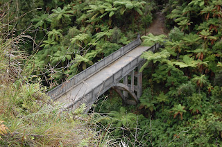
We jetted up river, surrounded by sheer cliff walls covered with lush vegetation.  At one point Ken took us up one of the tributaries feeding the river for a little side excursion.  He gave a through history of the area.  Our end destination was the "Bridge to Nowhere" which required a 40 minute hike through the brush once we reached the landing point. 

The surrounding hillside had been leased to soldiers returning from World War I who cultivated the area.  In the 1930s, the bridge was built to connect the community to the rest of the area, as the only access up until that point was via the river.  However, by the early '40s, rain and mudslides made the road so expensive to maintain, that the government abandoned the area and the inhabitants were forced to relocate.  Thus the bridge now leads to nowhere, however if you stand on the other side of the bridge, it leads to somewhere, where ever that may be.

Brian and I were quite lucky for the entire day over all, as it only misted a bit on our way to the bridge hike. In fact the sun did come out for a short period while we were doing our hike!  However, our ride back down the river was a different story.  The rain decided to come down in a more serious fashion, pelting our faces like tiny daggers.  It was a real test of our rain gear and I believe both of us weathered the storm very well.

Tomorrow, we set off for Queenstown on the south island to meet up with the rest of the people we will be traveling with for the next two weeks.  Looking forward to a relaxing evening of laundry (which Susie is doing for us) and hopefully a dip in the hot tub!

As a side note, the folks here in New Zealand as the nicest people I've ever run across.  And they set the standard when it comes to being polite.  Every time we pass through a construction zone, the sign at the end says "End Construction, Thank you."  Puts a smile on my face every time we pass through.